

Facsimile of hand-drawn map by Gen. Gordon
Item

Title
Facsimile of hand-drawn map by Gen. Gordon
map
Subject
Maps
map
Description
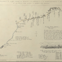
Facsimile of hand-drawn map by Gen. Gordon, illustrating route taken from the Red Sea to the Nile enroute to Khartoum. While drawn some time before the siege of Khartoum, it usefully illustrates the option, refused by Lord Wolseley, of a much shorter route for the Gordon Relief Expedition of 1884-5. [FN/ON/FHM 2019]


Publisher
Making African Connections
Date
This object has no date, but related object GGC130 reproduced in facsimile and published by Edward Stanford, 55, Charing Cross, London, S.W. February 17th 1885.
Type
PhysicalObject
Format
350 mm x 490 mm
Identifier
4801.111
GR111
Source

Language
Rights
© Royal Engineers Museum